[Today’s run: 3.4 miles]
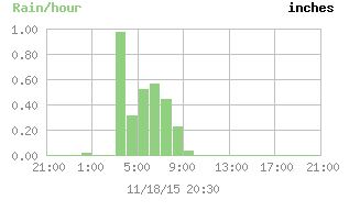
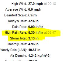
We had a heavy rain storm last night. A line of storms came through, I think around 2 AM. That included a tornado warning. But the rain really started closer to 3:30 AM and went on for quite awhile.
[Today’s run: 3.4 miles]
We had a heavy rain storm last night. A line of storms came through, I think around 2 AM. That included a tornado warning. But the rain really started closer to 3:30 AM and went on for quite awhile.
2 replies on “Heavy rain”
I was looking at topo map for the area to get a sense of where so much water would _go_ – and it appears to be Motley Slough to the west and south.
That is, “slough” if looking directly west of your place. If you go a bit fruther south on the map the name is Motley _SLU_. Weird.
https://www.topoquest.com/map-detail.php?usgs_cell_id=3372
Regardless, to the south the topo lines are pretty far from each other and is more like the Mississippi I have in my head.
Yes, our immediate topography is drainage to the south, rear of our property.
From there it goes to Motley Slough and then to the Tombigbee about 3 miles
east of here.
We are about 2 miles west of the river bottom area, and maybe 40? feet higher.
There is a bit of a ridge directly to the east of us about 1/4 mile.